|
|
 |
|
|
|
Our efforts are to serve as a first step toward the goal of integrating traffic, weather, and terrain information. Theoretically, by providing the flight crew with a display that integrates information about hazards in the airspace, they may be able to fly as safely and efficiently on a cloudy day as they would be able to fly on a clear day.Our group has generated nine recommendations pertaining to weather information in the flight deck of commercial aircraft based on past studies.
Recommendations for weather information in the cockpit:
- Obtain information that is based on multiple types of weather.
- Obtain information that is based on multiple sources of weather.
- Utilize an algorithm based on meteorological principles to create a meaningful integration of the various types of weather and various sources of weather.
- Include relevant, nonmeteorological variables in the integration algorithm.
Recommendations for displaying weather in the cockpit:
- Create and display general "hazard zones".
- Create and display "insufficient data" zones to inform the user that there is either no data or insufficient data to determine if an area is hazardous.
- Provide the flight crew with the ability to access the list of weather variables that are responsible for "creating" a hazard zone and/or any weather variables that might be available about an "insufficient data" zone.
- Allow the flight crew to view weather variables in isolation on an as needed basis.
- Display the age of the weather information on the display.
Integrating Traffic and Weather
The Proximity Compatibility Principle suggests that information sources should be either physically proximal when it is necessary to mentally integrate the information, or seperated when it is necessary to focus or divide one's attention on particular information. Clearly, weather and traffic are obstacles that both need be taken into consideration and avoided when navigating the airspace. To this end, the Flight Deck Display Laboratory team has generated recommendations for the integrated display of traffic and weather.
- Allow the flight crew to display weather and traffic information from various viewpoints, including a perspective (three-dimensional) viewpoint.
- Create visual momentum for transitions between viewing perspectives.
- Provide a readily-available weather decluttering option, and ensure adequate feedback is provided regarding whether or not weather currently is being rendered.
- The default rendering for hazardous weather zones and insufficient data weather zones should be semi-transparent.
- Provide a representation of forecasted hazard zones and their movement over time.
- Highlight portions of the aircraft's predictor line as a warning that the flight plan intersects with the position of a forecasted hazard zone.
- Provide a "what if" tool that allows for the assessment of rerouting options for the simultaneous avoidance of weather and traffic.
 |
 |
|
|
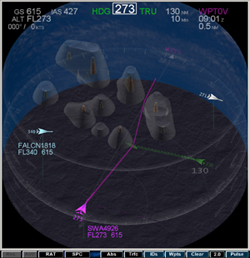
A screen caputre of the 3D Cockpit Situational Display, which integrates traffic and weather information. The large, redish "blob" represents an area of intense convective activity, and the grey area represents a buffer around which pilots should maneuver.
|
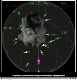
A Quicktime video showing the Weather Representation on the Cockpit Situational Display ( Quicktime - 4MB)
|
|
|
|